Complete Guide For New Homeowners: Horry County Floodplain Map
Living in Horry County, especially near the beautiful coast, offers both the charm of beachside living and the challenges associated with flooding. Understanding the local floodplain map is crucial for homeowners, as it influences construction decisions and insurance requirements. This complete guide will break down the intricacies of flood zones in Horry County, helping you make informed choices to protect your home and investment.
What is a Floodplain?
A floodplain is an area adjacent to a river, lake, or ocean that is prone to flooding. These areas are classified based on their risk levels, determined by historical flood data and geographical assessments. For a comprehensive understanding, visit the FEMA Floodplain Management page.
The Importance of the Horry County Floodplain Map
The Horry County Floodplain Map is essential for homeowners for several reasons:
- Risk Awareness: Knowing whether your property is in a high-risk flood zone can impact your home’s value and financial planning. Check out FEMA’s resources for more information.
- Regulatory Compliance: Properties in certain flood zones must adhere to specific building codes and regulations to minimize flood risk. Familiarize yourself with building codes relevant to Horry County.
- Insurance Requirements: Homeowners in designated flood zones often need to carry flood insurance, which can significantly affect annual costs. Learn more about flood insurance requirements.
Understanding Flood Zones in Horry County
Horry County uses the FEMA flood zone classification system, which includes several key designations relevant to local homeowners:
| Flood Zone | Description | Risk Level | Regulatory Implications | Local Area Implications |
|---|---|---|---|---|
| A | Areas with a 1% annual chance of flooding (100-year flood) | High | Mandatory flood insurance, elevation requirements | Areas like Myrtle Beach at risk |
| AE | Similar to A but with base flood elevations | High | Mandatory flood insurance, strict elevation standards | Sections of Socastee may be affected |
| X | Areas with a minimal risk of flooding | Low | Flood insurance optional but recommended | Inland regions like parts of Conway |
| V | Coastal areas at risk of storm surge | High | Elevated construction mandatory, stricter regulations | Coastal regions near the ocean |
Source: FEMA Flood Zone Definitions
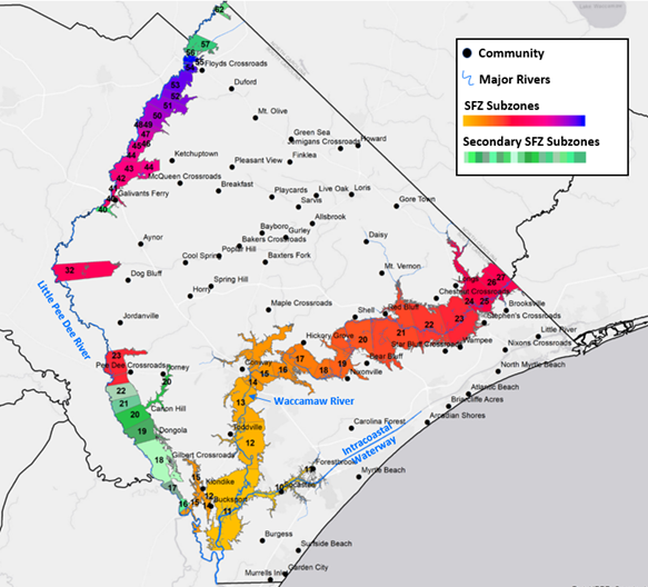
Understanding the Local Area and Floodplain Locations
Horry County is characterized by its coastal geography and numerous waterways, contributing to flooding risks. Key areas at higher risk include:
- Myrtle Beach: A popular tourist destination with high-risk flood zones, particularly near the oceanfront.
- Conway: Inland areas susceptible to flooding due to proximity to the Waccamaw River and its tributaries.
- Socastee: This low-lying area faces flood risks, especially during heavy rainfall and hurricanes.
For detailed maps outlining specific floodplain locations, visit the Horry County Floodplain Management page.
Accessing the Horry County Floodplain Map
Homeowners can view the Horry County Floodplain Map through the Horry County Planning Department’s website. This interactive map allows residents to identify their property’s flood zone and understand the associated risks.
Local Flood History and Statistics
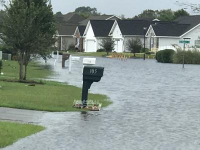
Understanding local flood history provides insight into risks faced by homeowners. Horry County has experienced significant flooding events, particularly during hurricane season. For example:
- Hurricane Florence (2018): Resulted in widespread flooding across Horry County, highlighting the vulnerabilities of many residential areas. Read FEMA’s Report on Hurricane Florence.
- Historical Data: According to FEMA, parts of Horry County experience flooding approximately every 10-20 years, depending on the location and specific weather events. Explore the National Flood Hazard Layer for detailed flood data.
Flood Risk Mitigation Strategies
1. Elevated Construction
- Homes in flood zones A and V are required to be elevated. The minimum elevation is typically at least one foot above the base flood elevation (BFE). For detailed guidelines, see the FEMA Elevation Certificate Information.
2. Flood-Resistant Materials
- Using materials that can withstand water damage, such as waterproof drywall and elevated HVAC systems, is crucial for homes in flood-prone areas. Review FEMA’s Guide on Flood-Resistant Materials for best practices.
3. Local Drainage Solutions
- Implementing proper drainage systems, including swales and retention ponds, can help mitigate flooding risk. Horry County encourages homeowners to consider these solutions during renovations and new builds. Find more information through Horry County Stormwater Management.
Insurance Implications
Homeowners in high-risk flood zones must carry flood insurance. It’s essential to understand the specifics of your coverage, including:
- National Flood Insurance Program (NFIP): Managed by FEMA, the NFIP provides flood insurance at subsidized rates for participating communities. Learn More about NFIP.
- Cost Considerations: Premiums can vary significantly based on the property’s elevation, flood zone classification, and claims history. For instance, homes in Zone A may see premiums ranging from $1,000 to $3,000 annually. Use the Flood Insurance Cost Estimator for more details.
Conclusion
Understanding the Horry County Floodplain Map is vital for homeowners to make informed construction and renovation decisions. By knowing your flood zone, the associated risks, and the regulatory requirements, you can protect your investment and ensure the safety of your home.
At Stroudswood Construction, we are committed to guiding homeowners through the complexities of residential construction in Horry County. With our expertise in local building codes, floodplain regulations, and resilient design solutions, we are a trusted partner for all your construction needs. Whether you’re considering a new build or a renovation, our team is here to help you navigate the process confidently and effectively.

Comments are closed